


A winter storm moves in from the west Thursday. A few light rain and snow showers are possible during the day with minimal accumulation. Snow starts to pick up after 4 p.m. for our western counties and after 6 p.m. closer to Lake Michigan. Winds will also increase with gusts near 35 mph, leading possibly to blowing snow. Snow will be heaviest between 9 p.m. and 6 a.m. Thursday night, before starting to taper down through the rest of Friday morning. Snow ends in the early afternoon Friday.
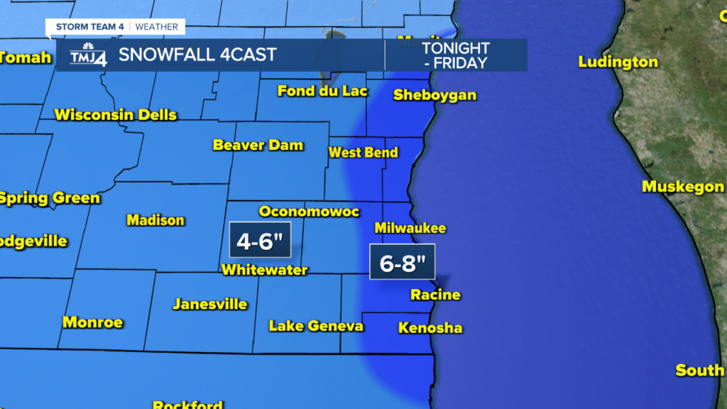
4-6″ of snow is expected for almost all of southeastern Wisconsin, with 6-8″ of snow closer to Lake Michigan. There is the possibility a few places could see 10″ within the area under the 6-8″ range. Be prepared for travel impacts starting late Thursday evening, with the highest impacts during the Friday morning commute. This will be a neutral snow, not dry and fluffy, nor heavy and wet.
{***A WINTER STORM WARNING IS IN EFFECT FOR KENOSHA, MILWAUKEE, OZAUKEE, RACINE, SHEBOYGAN, WASHINGTON, AND WAUKESHA COUNTIES FROM 6 P.M. THURSDAY TO 10 A.M. FRIDAY. 6-8″ OF SNOW IS EXPECTED, WITH HIGHER AMOUNTS NEAR 10″ POSSIBLE. DANGEROUS TRAVEL CONDITIONS ARE EXPECTED.***}
{***A WINTER WEATHER ADVISORY IS IN EFFECT FOR DODGE, FOND DU LAC, JEFFERSON, AND WALWORTH COUNTIES FROM 6 P.M. THURSDAY TO 9 A.M. FRIDAY. 4-6″ OF SNOW IS EXPECTED AND WILL CAUSE DANGEROUS TRAVEL CONDITIONS.***}
THURSDAY: Cloudy. Iso. rain/snow showers. Breezy
High: 40°
TONIGHT: Snow. Windy
Low: 31°
Wind: NE 15-20 G30 mph
FRIDAY: AM Snow. Breezy
High: 35°
Wind: NE 10-20 mph
SATURDAY: Partly sunny
High: 36°
SUNDAY: Snow. Breezy
Accum: 1-4″
High: 37°
Wind: SE 10-15 mph
MONDAY: Light snow. Breezy
Accum: <1″
High: 35°
