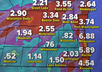
MILWAUKEE – Despite Southeast Wisconsin being in need of a steady rainfall, Monday’s all-day event may prove to be too much rain too fast.
A low pressure system is moving its way across the state this morning, bringing with it bands of rain that could present flooding concerns across the region. A Flood Watch is in effect for all of Southeast Wisconsin until 11pm this evening.
“I’m talking one to three inches of rainfall for much of the area, but I could see a couple of areas receiving a bit more than that.” TMJ4 Meteorologist Brendan Johnson said Monday morning. “There’s a concern that in our urban areas…if those storm drains are clogged, we’re looking at some street flooding. There’s also a potential for a bit of flash flooding across the area because the rainfall rates are going to be pretty impressive.”
Inland locations will likely deal with the first wave of flooding, followed by areas closer to Lake Michigan as an off-lake breeze helps fuel more consistent rainfall there this afternoon.
There’s also the potential for wind gusts around 30 miles per hour today, making beach conditions hazardous and possibly causing tree branches to fall on some power lines.
Stay tuned to WTMJ for complete Fleet Farm Storm Team Coverage of today’s rain. We’ll provide updated totals as they come in to the National Weather Service.


