


A WTMJ Fleet Farm Storm Team Alert: a Winter Storm Warning is in effect for all of Southeast Wisconsin from 6:00am Tuesday to 3:00am Wednesday.
It’s part of the first significant snowfall to impact the region this winter, and is expected to bring several inches of heavy, wet snow to the entire area.
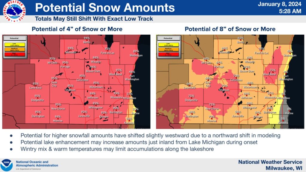
As of 5:30am, projections from the National Weather Service in Sullivan show areas away from Lake Michigan have the potential for over 8 inches of snow, while areas immediately along the lakeshore from Milwaukee on south will see lower amounts due to a relatively warm Lake Michigan for this time of year:
WTMJ Meteorologist Craig Koplien says the bulk of the snow will hold off until after midnight tonight, beginning in earnest after the morning commute Tuesday. “The heaviest snow is expected to fall in the early to mid-afternoon…and then it gradually starts to diminish after that and finally comes to an end around midnight tomorrow night” Koplein tells Wisconsin’s Morning News.
Koplien also says widespread power outages are not likely with this winter storm since snowfall rates will be less extreme than those seen around Halloween, when wet snow blanketed trees still carrying their leaves and leading to thousands left without power for hours in Milwaukee and elsewhere.
We’ll have more details throughout the day. Expect new watches, warnings, and advisories to be issued and more concrete snowfall totals to be announced later today.
TOP STORIES FROM THE WTMJ NEWSROOM:
- The Green Bay Packers are Playoff Bound
- Milwaukee Bucks & Good Karma Brands partner to introduce “Bucks+” audio
- Manhunt in Racine County after high-speed chase with infant in car
- Wisconsin’s Democratic governor says Trump should be on ballot, Biden must visit to beat him
- Charges filed after Lincoln Park standoff that left MPD officer injured


