


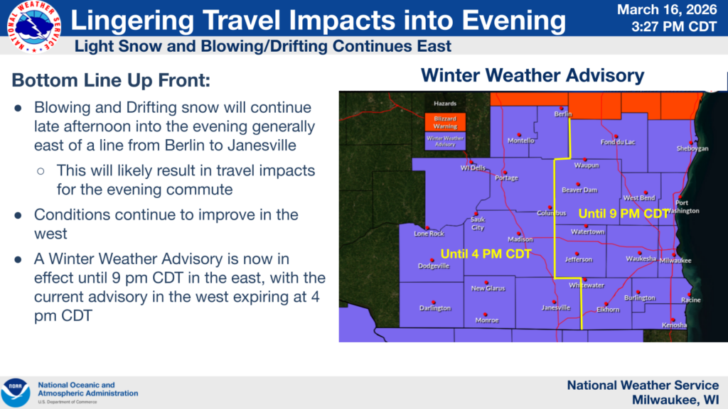
(UPDATE at 2:55 p.m. on 3/16/26) SULLIVAN, Wis. — The National Weather Service has canceled the Blizzard Warning for Southeast Wisconsin. All counties remain under a Winter Weather Advisory until 9 p.m. Monday.
(UPDATE at 7:30 p.m. on 3/15/26) SULLIVAN, Wis. — The National Weather Service has issued a Blizzard Warning for all of Southeast Wisconsin until 4 p.m. Monday.
Sleet-freezing rain transition continues to work southeast into the MKE metro early this evening, with conditions quickly becoming slippery. Changeover to snow continues across the northwest, where roads have become snow covered and slippery. Continue to avoid travel if possible! pic.twitter.com/y4dTdFcuNB
— NWS Milwaukee (@NWSMilwaukee) March 15, 2026
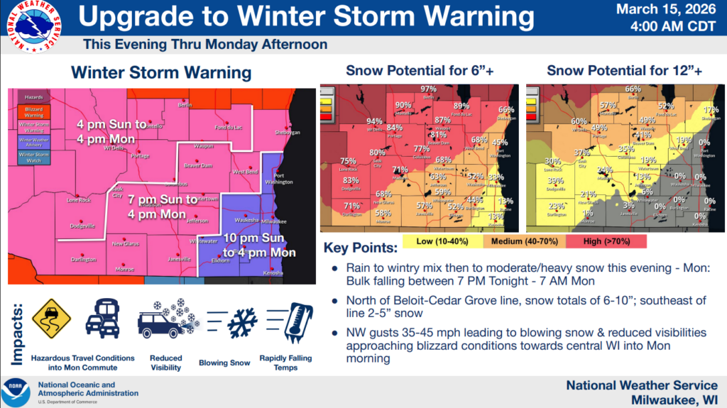
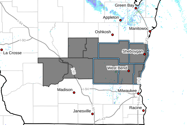
(UPDATE at 3:00 p.m. on 3/15/26) SULLIVAN, Wis. — The National Weather Service (NWS) has upgraded some of the Winter Weather watches and advisories to a Winter Storm Warning for Waukesha, Washington, Jefferson, Ozaukee, Walworth, Sheboygan, Dodge and Fond du Lac counties until 4 p.m. Monday.
NWS recommends delaying travel in these areas unless absolutely necessary. Roads are likely to become slick and blowing snow may cause visibility to drop below a quarter-mile.
Milwaukee, Racine and Kenosha counties remain under a Winter Weather Advisory until 4 p.m. Monday.
UPDATE 3-15-26 @9:40 A.M.
MILWAUKEE — A late-season winter storm continues to impact southern Wisconsin, with another round of snow expected overnight into Monday.
The National Weather Service says conditions will continue to shift throughout the day as warmer temperatures briefly move into the region before cold air returns Sunday night.
What’s Happening Now:
- Areas across southern Wisconsin saw 1 to 3 inches of snow overnight
- Some locations experienced sleet and freezing rain, creating slick roads and icy surfaces.
What to expect Sunday afternoon:
- Temperatures may rise into the 40s and low 50s.
- Rain and possible isolated thunderstorms could develop across southern Wisconsin.
What to expect Sunday night into Monday:
- Much of southern Wisconsin is now under a Winter Storm Warning.
- Southeast Wisconsin remains under a Winter Weather Advisory.
- 2 to 5 inches of snow are possible in southeast Wisconsin, including Milwaukee.
- Areas farther north and west could see 6 to 10 inches of snow.
- Strong winds up to 45 mph could cause blowing and drifting snow.
Forecasters say the heaviest snowfall is expected overnight through early Monday morning, with conditions gradually improving later Monday.
MILWAUKEE — The National Weather Service provides updates on the latest winter weather advisories and watches.
A Winter Weather Advisory will start on Saturday, March 14 at 7:00 p.m. and be in effect until Saturday, March 15 until 10:00 a.m. for Ozaukee, Sheboygan, Fond du Lac County, and Dodge Counties.
Then a Winter Storm Watch will take effect starting at 4:00 p.m. on March 15 until 7:00 p.m. for all of Southeast Wisconsin.
A strong late winter storm system is expected to impact southern Wisconsin during the last half of the weekend in 3 phases:
- The first phase will run from the evening of Saturday, March 14 into the morning of Sunday, March 15 and will feature a Winter Weather Advisory. Snow accumulations of 1 to 3 inches are expected in the advisory area, along with the potential for a up to a tenth of an inch of ice accumulation.
- The second phase is then expected from late in the morning on Sunday, March 15 into the afternoon. Warm air causes a transition to rain over a majority of southern Wisconsin, and there is a possibility of thunderstorms.
- The last phase will then run from the late afternoon on Sunday, March 15 through Monday, March 16, as cold air then wraps back into the area and heavy banded snow moves in. Snowfall totals are expected to be from 5 to 9 inches, with the possibility of a light glaze of ice especially over central and east central Wisconsin. Wind gusts up to 45 mph will cause blowing snow and visibility issues.
Severe weather coverage on WTMJ is presented by Fleet Farm.
