
UPDATE @ 1:45 P.M. 7-27-26: All Tornado Warnings have now expired.
UPDATE @ 1:08 P.M.: The National Weather Serice has issued a Tornado Warning for Western Fond du Lac and Dodge County until 1:45p.m.
Tornado Warning including Beaver Dam WI, Waupun WI and Ripon WI until 1:45 PM CDT pic.twitter.com/Q6uhVKtb6c
— NWS Milwaukee (@NWSMilwaukee) July 27, 2026
Trained weather spotters on the ground reported seeing a funnel cloud with this storm.
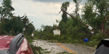
Flying debris will be dangerous to those caught without shelter. Mobile homes will be damaged or destroyed. Damage to roofs, windows, and vehicles will occur. Tree damage is likely.
This dangerous storm will be near Rosendale and Brandon around 1:10 p.m. Waupun and Oakfield around 1:15 p.m.
Other locations impacted by this tornadic thunderstorm include Kekoskee, Eldorado, Atwater, Oak Center, Brownsville, Burnett, Fairwater, Lagoda, Knowles, and South Beaver Dam.
Other landmarks included are the following Location Horicon Marsh.
SULLIVAN, Wis— The National Weather Serice has issued a Tornado Warning for Fond du Lac County until 1:30 p.m.
Tornado Warning including Fond du Lac WI, North Fond du Lac WI and Campbellsport WI until 1:30 PM CDT pic.twitter.com/7izEs9ytNx
— NWS Milwaukee (@NWSMilwaukee) July 27, 2026
Flying debris will be dangerous to those caught without shelter. Mobile homes will be damaged or destroyed. Damage to roofs, windows, and vehicles will occur. Tree damage is likely.
This dangerous storm will be near Fond Du Lac, North Fond Du Lac, and Southern Lake Winnebago around
12:50 p.m. Campbellsport around 1:05 p.m.
Other locations impacted by this tornadic thunderstorm include Byron, Peebles, Mount Calvary, Eden, Dundee, Ashford, Pipe, Waucousta, Taycheedah, and Calvary.