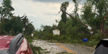


UPDATE at 4:10 p.m. on 7/27/26: The National Weather Service issues a Severe Thunderstorm Warning for Waukesha County until 4:45 p.m.
Severe Thunderstorm Warning including Waukesha WI, Muskego WI and Hartland WI until 4:45 PM CDT pic.twitter.com/tq1GncWq0X
— NWS Milwaukee (@NWSMilwaukee) July 27, 2026
At 4:05 p.m., a severe thunderstorm was located near Waukesha, moving southeast at 20 mph with quarter size hail.
UPDATE at 3:58 p.m. on 7/27/26: The Severe Thunderstorm Warning has expired for Jefferson and Waukesha counties. It remains in effect for Kenosha, Racine and Walworth counties until 4:15 p.m.
UPDATE at 3:03 p.m. on 7/27/26: The National Weather Service issues a Severe Thunderstorm Warning for Kenosha, Racine, Walworth, Jefferson and Waukesha counties until 4:15 p.m.
Severe Thunderstorm Warning including Burlington WI, Elkhorn WI and Delavan WI until 4:15 PM CDT. This storm will contain wind gusts to 70 MPH and tennis ball sized hail! pic.twitter.com/3TkZAP0D0x
— NWS Milwaukee (@NWSMilwaukee) July 27, 2026
At 2:56 p.m., a severe thunderstorm was located over Ottawa near Wales, moving south at 40 mph with tennis ball size hail and 70 mph wind gusts.
UPDATE at 2:46 p.m. on 7/27/26: The National Weather Service issues a Severe Thunderstorm Warning for Dodge and Jefferson counties until 3:15 p.m., and for Milwaukee, Waukesha, and Racine counties until 3:30 p.m.
Severe Thunderstorm Warning including Watertown WI, Fort Atkinson WI and Jefferson WI until 3:15 PM CDT. This storm will contain wind gusts to 70 MPH and tennis ball sized hail! pic.twitter.com/AubK1wFHMM
— NWS Milwaukee (@NWSMilwaukee) July 27, 2026
At 2:34 p.m., a severe thunderstorm was located near Lac La Belle, or near Watertown, moving south at 40 mph, with tennis ball size hail and 70 mph wind gusts as the main hazards.
Severe Thunderstorm Warning including Racine WI, Mount Pleasant WI and Caledonia WI until 3:30 PM CDT pic.twitter.com/3ZLPUsvwNL
— NWS Milwaukee (@NWSMilwaukee) July 27, 2026
At 2:42 p.m., severe thunderstorms were located along a line extending from Cudahy to Hales Corners, moving southeast at 40 mph, with 60 mph wind gusts and quarter size hail.
UPDATE at 2:03 p.m. on 7/27/2026: The National Weather Service issues a Severe Thundestorm Warning for Milwaukee and Waukesha counties until 3:30 p.m.
Severe Thunderstorm Warning including Milwaukee WI, Waukesha WI and West Allis WI until 3:30 PM CDT pic.twitter.com/GdMIkhwUO5
— NWS Milwaukee (@NWSMilwaukee) July 27, 2026
At 1:59 p.m., severe thunderstorms were located along a line extending from near Cedarburg to near Hartford, moving south at 25 mph. Storms include 60 mph wind gusts and quarter size hail.
Severe Thunderstorm Warnings have now been cancelled for Sheboygan and Fond du Lac counties.
UPDATE at 1:28 p.m. on 7/27/2026: The National Weather Service has issued Severe Thunderstorm Warnings for Sheboygan and Fond du Lac counties until 2:15 p.m.
Severe Thunderstorm Warning including Fond du Lac WI, Waupun WI and Ripon WI until 2:15 PM CDT. This destructive storm will contain wind gusts to 80 MPH! pic.twitter.com/CGGpb60wFf
— NWS Milwaukee (@NWSMilwaukee) July 27, 2026
Severe Thunderstorm Warning continues for West Bend WI, Mequon WI and Germantown WI until 2:30 PM CDT. This destructive storm will contain wind gusts to 80 MPH! pic.twitter.com/scOIwEW0YU
— NWS Milwaukee (@NWSMilwaukee) July 27, 2026
Flying debris will be dangerous to those caught without shelter. Mobile homes will be heavily damaged. Expect considerable damage to roofs, windows, and vehicles. Extensive tree damage and power outages are likely.
Locations impacted include Fond Du Lac, Waupun, Ripon, North Fond Du Lac, Oostburg, Cedar Grove, Campbellsport, Random Lake, Oakfield, Rosendale, Brandon, Southern Lake Winnebago, Taycheedah, Ashford, Lamartine, Byron, Eldorado, Alto, Eden, and Cascade.
UPDATE at 1:02 P.M.: The National Weather Service has issued Severe Thunderstorm Warnings for Ozaukee, Washington and Dodge counties until 2:30 p.m.
Severe Thunderstorm Warning including West Bend WI, Mequon WI and Germantown WI until 2:30 PM CDT. This destructive storm will contain wind gusts to 80 MPH! pic.twitter.com/rbcLgNvZcY
— NWS Milwaukee (@NWSMilwaukee) July 27, 2026
Severe Thunderstorm Warning continues for Sheboygan WI, Fond du Lac WI and Plymouth WI until 1:30 PM CDT. This destructive storm will contain wind gusts to 80 MPH! pic.twitter.com/tFos46tb3Z
— NWS Milwaukee (@NWSMilwaukee) July 27, 2026
UPDATE @ 12:35 P.M.: The National Weather Service says Severe Thunderstorm Warnings continue for Kenosha County until 1:15 PM.
Severe Thunderstorm Warning continues for Kenosha WI, Pleasant Prairie WI and Bristol WI until 1:15 PM CDT. This storm will contain tennis ball sized hail! pic.twitter.com/azTyqIFvUH
— NWS Milwaukee (@NWSMilwaukee) July 27, 2026
The National Weather Service has issued a Severe Thunderstorm Watch for Ozaukee, Sheboygan and Fond du Lac counties until 7 p.m.
UPDATE @ 12:16 P.M.: Kenosha and Racine County are under thunderstorm watch until 1:15 PM. Sheboygan and Fond du Lac Counties are until 1:30 PM.
Severe Thunderstorm Warning including Kenosha WI, Racine WI and Mount Pleasant WI until 1:15 PM CDT pic.twitter.com/dKxuc6aBBY
— NWS Milwaukee (@NWSMilwaukee) July 27, 2026
The National Weather Service has issued a Severe Thunderstorm Watch for Ozaukee, Sheboygan and Fond du Lac counties until 7 p.m.
UPDATE @11:00 A.M. 7-27-26— The National Weather Service has issued a Severe Thunderstorm Warning for a majority of Southeast Wisconsin until 12:15 p.m. Monday.
Severe Thunderstorm Warning including West Bend WI, Mequon WI and Germantown WI until 12:15 PM CDT pic.twitter.com/w7cTPCFrWw
— NWS Milwaukee (@NWSMilwaukee) July 27, 2026
Severe Thunderstorm Warning including Kenosha WI, Racine WI and Mount Pleasant WI until 12:15 PM CDT pic.twitter.com/EWWvlzEFAd
— NWS Milwaukee (@NWSMilwaukee) July 27, 2026
Severe Thunderstorm Warning including Milwaukee WI, Waukesha WI and West Allis WI until 12:15 PM CDT pic.twitter.com/xC4LBGSIae
— NWS Milwaukee (@NWSMilwaukee) July 27, 2026
UPDATE @10:41 a.m. 7-27-26— The National Weather Service has issued a Severe Thunderstorm Warning for Southeast Wisconsin until 11:15 a.m.
Severe Thunderstorm Warning including Germantown WI, Hartford WI and Richfield WI until 11:00 AM CDT pic.twitter.com/sWjPJjQEWJ
— NWS Milwaukee (@NWSMilwaukee) July 27, 2026
Severe Thunderstorm Warning including Kenosha WI, Racine WI and Mount Pleasant WI until 11:15 AM CDT pic.twitter.com/SLDjGqyKO6
— NWS Milwaukee (@NWSMilwaukee) July 27, 2026
SULLIVAN, Wis.— The National Weather Service has issued a Severe Thunderstorm Warning for Waukesha and Jefferson Counties until 11 a.m.
Severe Thunderstorm Warning including Waukesha WI, New Berlin WI and Brookfield WI until 11:00 AM CDT pic.twitter.com/UWjSWmQNkZ
— NWS Milwaukee (@NWSMilwaukee) July 27, 2026
A Severe Thunderstorm Warning is in effect for Washington and Dodge Counties until 11:15 a.m.