


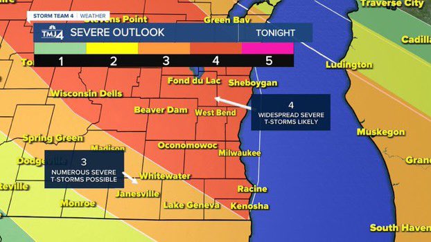
Almost all of southeast Wisconsin is now in the moderate risk (4 out of 5) category for severe thunderstorms tonight.
Widespread severe thunderstorms are likely after 10 p.m.
Marisa Woloszyn of TMJ4 News says: “The biggest threat is wind gusts 58+ mph, especially if a derecho develops, and hail greater than 1″ in diameter. There is a a chance for a few tornadoes as well. As for timing, storms will enter our area from the northeast around 10 p.m., move through downtown Milwaukee around 11-12 p.m., and then move out of the area around 3-4 a.m. It is important for people to have a plan in place and have a weather radio or severe weather alerts activated on their cell phones, as severe weather is likely when many will be sleeping.”
Stay tuned to WTMJ for updates.
Strong winds and large hail are likely tonight, but I’m also not going to rule out possible tornadoes and localized flash flooding. @tmj4 pic.twitter.com/S9GnD1Mqo6
— Marisa Woloszyn (@MarisaWoloszyn) July 28, 2021
Here’s a look at the likely timing of tonight’s severe weather. Expect gusty winds, large hail, and possible tornadoes. @tmj4 pic.twitter.com/MR9Ep2aORU
— Marisa Woloszyn (@MarisaWoloszyn) July 28, 2021
I hope you guys know me well enough by now to know I’m not some crazy over alarmist.
— Brian Niznansky (@BrianNizTMJ4) July 28, 2021
So I don’t say this lightly…. but tonight’s storms will have the potential to do some widespread damage. pic.twitter.com/kcFM5KSiQd


