


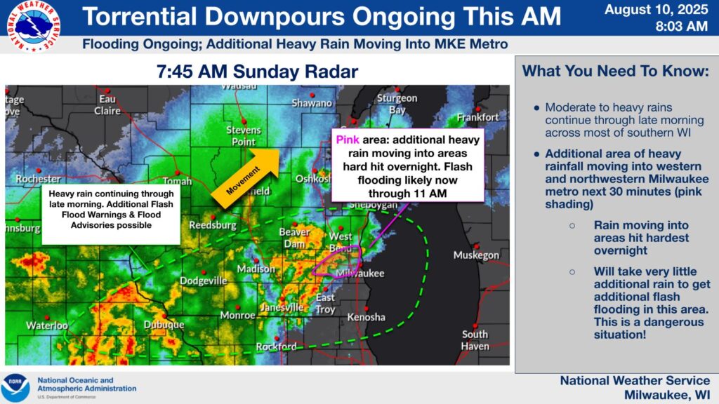
UPDATE at 9:30 a.m. on 8/10/25: The National Weather Service extends the Flood Warning for Ozaukee and Washington Counties until 12:30 p.m.

Flooding of rivers, creeks, streams, and other low-lying and flood-prone locations is occurring. Numerous roads remain closed due to flooding. Streams continue to rise due to excess runoff from earlier rainfall.
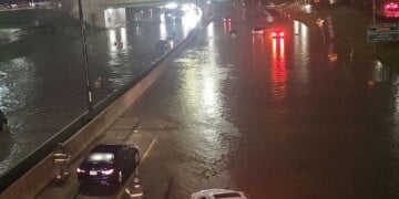
At 9:19 a.m., authorities reported that numerous roads were closed due to the flooding, especially after 4-7 inches of rain had fallen.
UPDATE at 9:00 a.m. on 8/10/25: The National Weather Service continues Flash Flood Warnings for Dodge, Washington, and Waukesha Counties until 12:00 p.m.
Flash Flood Warning including Oconomowoc WI, Hartford WI and Hartland WI until 12:00 PM CDT pic.twitter.com/IBP951dlEV
— NWS Milwaukee (@NWSMilwaukee) August 10, 2025
At 8:55 a.m. , Doppler radar and automated rain gauges indicated thunderstorms producing heavy rain across the warned area with between 1 and 2.5 inches of rain having fallen. The expected rainfall rate is 1 inch in 1 hour. Additional rainfall amounts of 1 to 2 inches are possible in the warned area. Flash flooding is ongoing or expected to begin shortly due to the storms.
UPDATE at 8:10 a.m. on 8/10/25: The National Weather Service extends a Flash Flood Warning for Milwaukee, Waukesha and Ozaukee Counties until 11:00 a.m.
Flash Flood Warning including Menomonee Falls WI, Germantown WI and Richfield WI until 11:00 AM CDT pic.twitter.com/9O1AeGfILA
— NWS Milwaukee (@NWSMilwaukee) August 10, 2025
The National Weather Service expects more torrential downpours to continue in Southeast Wisconsin.
UPDATE at 5:10 a.m. on 8/10/25: The National Weather Service issues a Flash Flood Warning for Ozaukee County until 8:15 a.m.
Flash Flood Warning including West Bend WI, Grafton WI and Port Washington WI until 8:15 AM CDT pic.twitter.com/dgxGOkgYrn
— NWS Milwaukee (@NWSMilwaukee) August 10, 2025
UPDATE at 3:30 a.m. on 8/10/25: The National Weather Service warns of continued storms with heavy rainfall and flooding across portions of southern Wisconsin. Storms that impacted areas in the Milwaukee metro area are moving northeast.

Street flooding and possible flash flooding are the main hazards from the storms.
UPDATE at 2:45 a.m. on 8/10/25: The National Weather Service issues a Flood Warning for the Kinnickinnic River in Milwaukee. Major flooding is occurring, since the river is at 16.6 feet, which is 2 feet over the top of the concrete-lined channel. The flood waters are affecting homes in the neighborhood adjacent to the river.
UPDATE at 1:40 a.m. on 8/10/25: The National Weather Service extends a Flash Flood Warning to Ozaukee and Washington Counties until 5:30 a.m.
Flash Flood Warning including Mequon WI, Germantown WI and Cedarburg WI until 5:30 AM CDT pic.twitter.com/AaPkpEQ85x
— NWS Milwaukee (@NWSMilwaukee) August 10, 2025
At 1:38 a.m., Doppler radar and automated rain gauges indicated thunderstorms producing heavy rain across the warned area after 1-3 inches of rain had already fallen. Additional rainfall amounts of 1.5 to 3 inches are possible in the warned area. Flash flooding is ongoing or expected to begin shortly caused by the thunderstorms.
Flash flooding is likely in small creeks and streams, urban areas, highways, streets and underpasses as well as other poor drainage and low-lying areas.
Precautions include not trying to drive through flooded streets, since most flood deaths occur in vehicles. Be especially cautious at night when it is harder to recognize the dangers of flooding.
UPDATE at 1:20 a.m. on 8/10/25: The National Weather Service extends the Flood Warnings for Milwaukee and Waukesha Counties “until further notice”.
Flooding is occurring from the Menomonee River in Wauwatosa, swelling out of its banks and flooding surrounding lowlands at around 11 feet. The banks are usually at 8 feet. The Menomonee River is also above flood stage in Menomonee falls at 7.6 feet.
Minor flooding is also occurring on the Fox River in Waukesha, with 7 feet of water over the banks at Frame Park, and floodwaters at least 2 feet deep on land near the shoreline. About one half mile south of downtown Waukesha, water is 2 to 3 feet deep and covering much of the back yards of 6 or 7 homes in the Bethesda Court area of Waukesha.
Storms with heavy rainfall continue across the Milwaukee metro area. They continue to regenerate on the southwest side of the area of storms and may move over the same areas overnight. Flash flooding is the main hazard. Turn Around, Don't Drown! #swiwx #wiwx pic.twitter.com/svBfgvbiRY
— NWS Milwaukee (@NWSMilwaukee) August 10, 2025
UPDATE at 1:10 a.m. on 8/10/25: The National Weather Service extends the Flash Flood Warning for Milwaukee and Waukesha Counties until 5:00 a.m. on August 10.
Flash Flood Warning including Milwaukee WI, Waukesha WI and West Allis WI until 5:00 AM CDT pic.twitter.com/TGQSdVMy7k
— NWS Milwaukee (@NWSMilwaukee) August 10, 2025
At 1:07 a.m., Doppler radar and automated rain gauges indicated thunderstorms producing heavy rain. Numerous street and creek flooding, basement flooding, and some stranded vehicles reported, since 3 to 6 inches of rain have fallen in the area. Additional rainfall amounts of 1 to 2 inches are possible in the warned area. Flash flooding is already occurring that can be life threatening with these thunderstorms.
UPDATE at 11:15 p.m. on 8/9/25: The National Weather Service extends the Flash Flood Warning for Waukesha County until 3:00 a.m.
Flash Flood Warning including Waukesha WI, Pewaukee WI and Sussex WI until 3:00 AM CDT pic.twitter.com/Oa9cLomEYc
— NWS Milwaukee (@NWSMilwaukee) August 10, 2025
MILWAUKEE — The National Weather Service has issued a flash flood warning for Milwaukee and Waukesha Counties until 2:00am on August 10.
Flash Flood Warning including Milwaukee WI, West Allis WI and Wauwatosa WI until 2:00 AM CDT pic.twitter.com/93VbZPzVnK
— NWS Milwaukee (@NWSMilwaukee) August 10, 2025
At 8:04 p.m., Doppler radar indicated thunderstorms producing heavy rain across the warned area where between 1 and 1.5 inches of rain have fallen. The expected rainfall rate is 1 to 2 inches per hour. Flash flooding is ongoing or expected to begin shortly because of the storms.
Flash flooding can occur in areas of small creeks and streams, urban areas, highways, streets and underpasses as well as other poor drainage and low-lying areas.
Severe weather coverage is sponsored by Fleet Farm.
