


UPDATE at 7:57 p.m. on 7/11/25: The National Weather Service issues a Severe Thunderstorm Warning for Milwaukee, Waukesha, Ozaukee, Washington and Dodge counties until 8:45 p.m.
UPDATE at 7:15 p.m. on 7/11/25: The National Weather Service issues a Severe Thunderstorm Warning for Dodge, Jefferson, and Waukesha Counties until 8:00 p.m.
Severe Thunderstorm Warning including Watertown WI, Oconomowoc WI and Fort Atkinson WI until 8:00 PM CDT. This storm will contain wind gusts to 70 MPH! pic.twitter.com/Y5nC0rIeaw
— NWS Milwaukee (@NWSMilwaukee) July 12, 2025
At 7:12 p.m. , severe thunderstorms were located along a line extending from near Lake Ripley to near Fort Atkinson to Whitewater, moving northeast at 40 mph. The hazards include 70 mph wind gusts and nickel size hail.
Expect considerable tree damage. Damage is likely to mobile homes, roofs, and outbuildings.
UPDATE at 7:03 p.m. at 7/11/25: The National Weather Service issues a Severe Thunderstorm Warning for Walworth, Jefferson, and Waukesha Counties until 7:45 p.m.
Severe Thunderstorm Warning continues for Janesville WI, Beloit WI and Milton WI until 7:30 PM CDT. This storm will contain wind gusts to 70 MPH! pic.twitter.com/sMDsXHyNy1
— NWS Milwaukee (@NWSMilwaukee) July 12, 2025
At 6:59 p.m. severe thunderstorms were located along a line extending from near Lake Koshkonong to near Clinton to 6 miles northeast of Roscoe, moving east at 45 mph. Hazards include 70 mph wind gusts and nickel size hail.
UPDATE at 6:45 p.m. at 7/11/25: The National Weather Service issues a Tornado Warning for Jefferson County until 7:30 p.m.
Tornado Warning including Fort Atkinson WI, Milton WI and Edgerton WI until 7:30 PM CDT pic.twitter.com/Q8ubmuuQgl
— NWS Milwaukee (@NWSMilwaukee) July 11, 2025
At 6:42 p.m., severe thunderstorms capable of producing a tornado were located along a line extending from near Evansville to 6 miles south of Edgerton to near Janesville, moving northeast at 40 mph.
Flying debris will be dangerous to those caught without shelter. Mobile homes will be damaged or destroyed. Damage to roofs, windows, and vehicles will occur. Tree damage is likely.
UPDATE at 6:35 p.m. at 7/11/25: The National Weather Service issues a Severe Thunderstorm Warning for Jefferson County until 7:15 p.m.
Severe Thunderstorm Warning including Fitchburg WI, Oregon WI and Belleville WI until 7:15 PM CDT. This storm will contain wind gusts to 70 MPH! pic.twitter.com/HVYyPw4e6h
— NWS Milwaukee (@NWSMilwaukee) July 11, 2025
SULLIVAN, Wis. — The National Weather Service has issued a Tornado Watch for Kenosha, Racine, Milwaukee, Walworth, Waukesha, and Jefferson Counties until 11pm.
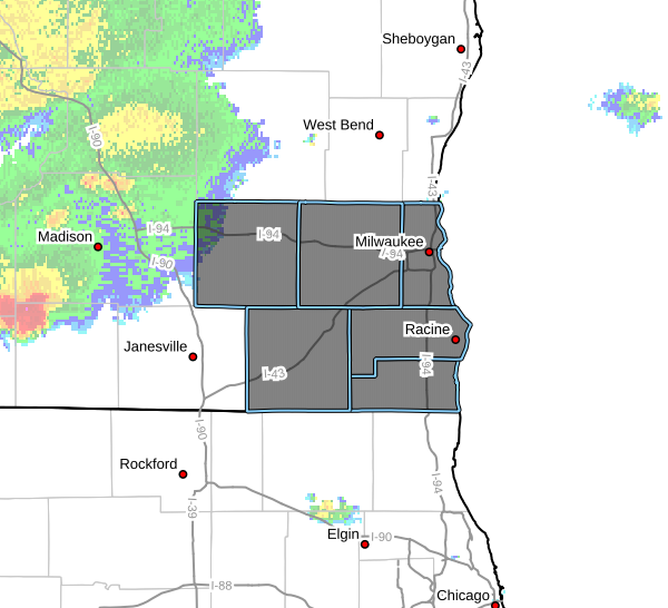
A tornado watch has been issued for parts of Illinois and Wisconsin until 11 PM CDT pic.twitter.com/d8JFe0EvQx
— NWS Milwaukee (@NWSMilwaukee) July 11, 2025
The primary concerns are up to ping-pong-size hail and scattered wind gusts up to 75 mph.
Severe weather coverage is sponsored by Fleet Farm.