


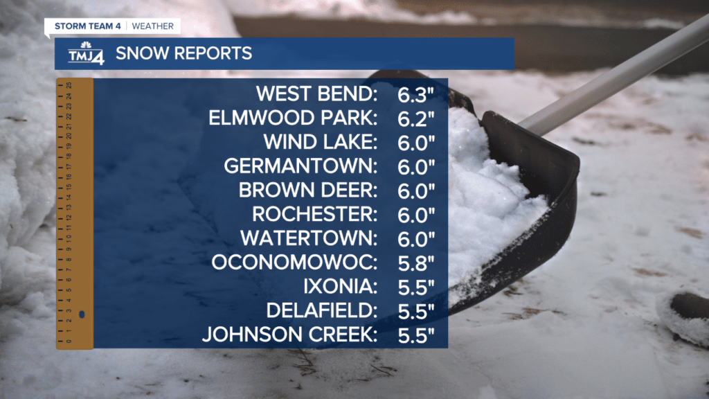
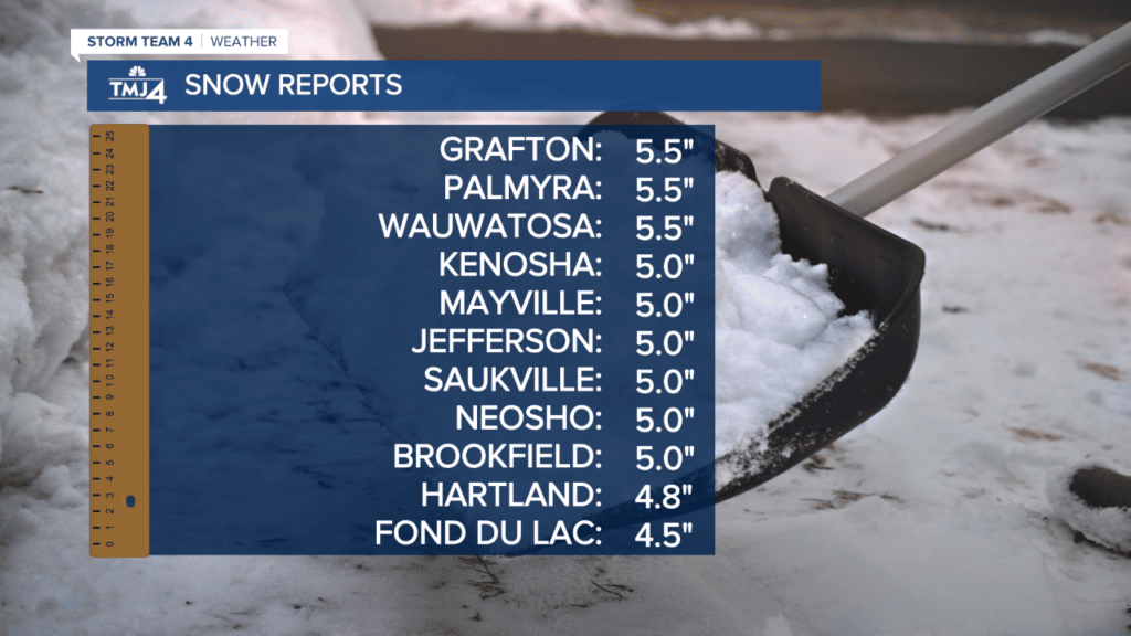
The snowfall that began Thursday morning eventually tapered off around midnight. The latest snow totals below courtesy of our news partners at TMJ4.


UPDATE at 2:45 p.m. on Feb. 16, 2023: The Winter Storm Warning for much of Southeast Wisconsin has been extended into Thursday night and early Friday morning.
As per the National Weather Service, this warning will now subside at 10:00 p.m. for Walworth, Jefferson and Waukesha counties. That warning has been pushed back to midnight for Kenosha, Racine, Ozaukee and Milwaukee counties.
The snowfall was initially predicted to land between 3 and 7 a.m. for most of Southeast Wisconsin, though it eventually picked up between 8 and 9 a.m. Now, the snowfall has a chance to linger through the night into the early morning — particularly for lakefront communities.
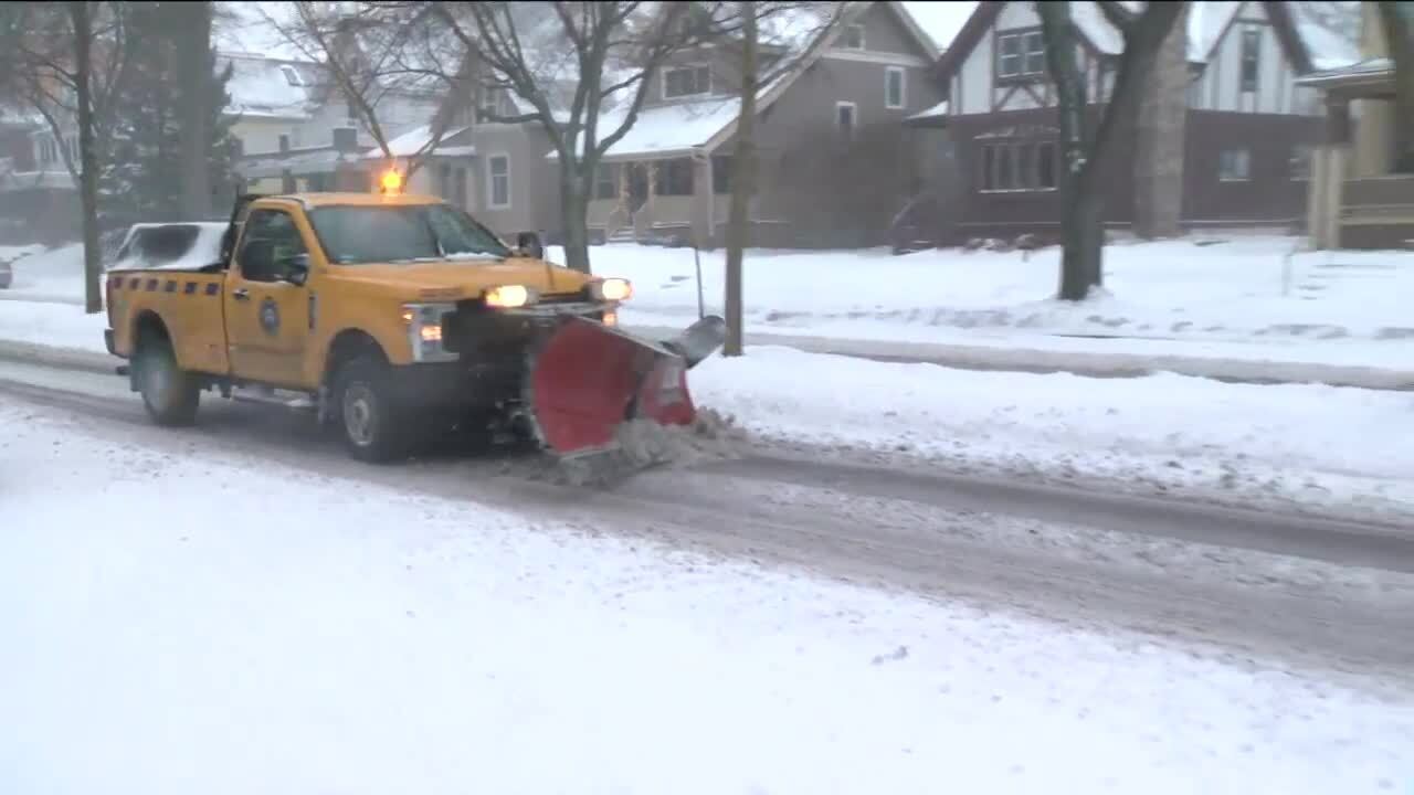
Poor visibility and slick road conditions have been a major factor for drivers throughout the day thus far.
CLOSINGS: Click to find a list of closings, courtesy of our partners at TMJ4 News
A winter storm will bring steady snow and gusty winds Thursday, likely causing dangerous travel conditions across the area.
Snow starts in the morning, with the heaviest snow around midday and the afternoon. Areas with the highest expected snowfall could see snowfall rates 1-1.5″ an hour during the afternoon.
There will be a sharp cut-off to the northwest in snowfall amounts. So even though there is a good chance for a few inches of snow through Beaver Dam and Fond du Lac, there is also the potential these locations could see nothing.
Snow will start to end from west to east around 6 p.m., eventually ending by the lakefront by 11 p.m. Blowing snow is possible with northeast winds 15-25 mph, with gusts near 35 mph.
⚠️Today is the day for the Winter Storm, if heading out the door this morning be prepared for snow to pick up this afternoon likely impacting the evening commute especially across southern & eastern WI. ❄️#wiwx pic.twitter.com/36VCIowd0C
— NWS Milwaukee (@NWSMilwaukee) February 16, 2023
***A WINTER STORM WARNING HAS BEEN ISSUED FOR JEFFERSON, KENOSHA, MILWAUKEE, OZAUKEE, RACINE, WALWORTH, WASHINGTON, AND WAUKESHA COUNTIES STARTING AT 9 A.M. 4-8″ OF SNOW, WITH LOCALLY HIGHER AMOUNTS NEAR 10″ ARE POSSIBLE. WINDS COULD GUST AS HIGH AS 35 MPH. DANGEROUS DRIVING CONDITIONS ARE LIKELY.***
***A WINTER WEATHER ADVISORY HAS BEEN ISSUED FOR DODGE, FOND DU LAC, AND SHEBOYGAN COUNTIES STARTING AT 9 A.M. 1-4″ OF SNOW IS EXPECTED IN THIS AREA. HAZARDOUS DRIVING CONDITIONS ARE LIKELY.***
INCLEMENT WEATHER COMING: Friends, if you have to be on the road Thursday, when as much as 10 inches of snow is forecast for parts of Wisconsin, make a plan! Here are a few tips to help improve your safety and prepare you in case you’re out there longer than intended: pic.twitter.com/YKLpwiyHcT
— Milwaukee County Sheriff’s Office (@MilwCoSheriff) February 16, 2023
WTMJ 5-Day Forecast:
THURSDAY: Snow. Windy
High: 31°
Wind: NE 15-25 G35 mph
TONIGHT: Mostly clear. Windy
Low: 15°
Wind: N 10-20 G35 mph
FRIDAY: Mostly sunny. Breezy
High: 25°
Wind: N 10-15 mph
SATURDAY: Increasing clouds. Breezy
High: 41°
Wind: SW 10-20 G35 mph
SUNDAY: Mostly cloudy. Flurries
High: 43°
Wind: SW 10-15 mph
MONDAY: Mostly cloudy. Flurries
High: 40°


